The Wisconsin River just south of Lone Rock, Wisconsin, provides a spectacular backdrop for a shot of the author's 883R Sportster. Photography by Gary Ilminen.
If you’re a rider in the upper Midwest and you anticipate riding in warm temperatures under crystal clear blue skies in November, you fall into the category of “optimistic.” Maybe make that “wildly optimistic.” November hereabouts is much better known for slate-gray skies and winds out of the north, with freezing rain turning to snow.
Yet, it does happen—on November 14, for example. With cloudless, sunny skies and a gentle south breeze wafting warm air northward, much of the upper Midwest found itself basking in weather that could be mistaken for an early summer day—in the fall, it is known as Indian Summer. Depending on where you were in the region, temperatures reached the upper 60s, about 20 degrees above average for the date.
My friend, Tom Kelly, a devoted Moto Guzzi rider and owner of a newly-acquired 2017 Moto Guzzi V9, had already organized a group early-day ride from Spring Green, Wisconsin, to Galena, Illinois—about 150 miles round trip. I often join these rides, as Tom has a knack for taking great routes to interesting destinations. But, on this morning, I had other things going on that put my ride time off till about noon. So, I missed that one. However, not to let such a perfect ride day go unenjoyed, I mounted up on my Harley-Davidson XL883R Sportster around noon and headed out on what I think of as the Blue Mounds Loop.
The XL883R is a do-it-all kind of bike, great for both daytrip touring and long-range work. With a rubber-mounted engine, EFI, a comfy saddle, long-travel suspension, excellent handling, and good brakes, the bike takes the traditional Sportster’s strength as a long-stroke lopper to a new level.
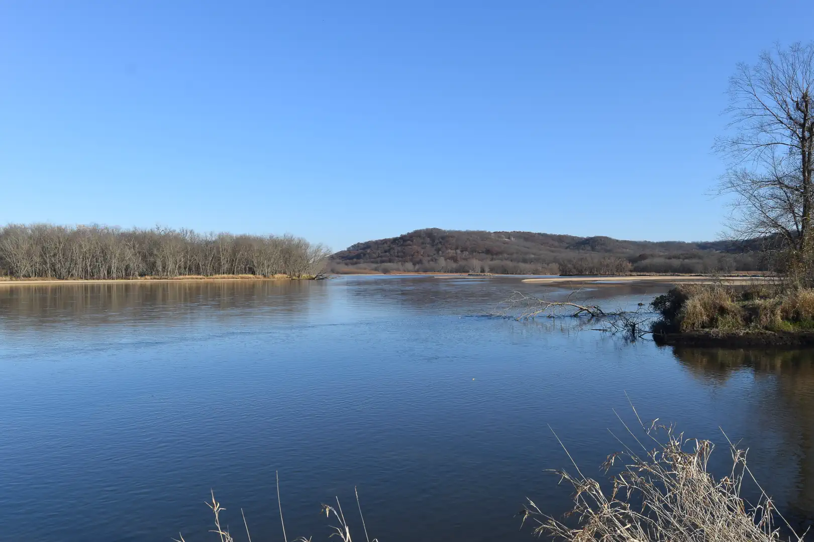
The Wisconsin River is a placid, inviting place at the public boat landing south of Lone Rock.
I didn’t have to go far to find a place to stop and soak in the warmth and color of the sky and the Wisconsin River. The Wisconsin is one of the world’s more unique rivers. It flows about 430 miles from Lac Vieux Desert in Michigan’s Upper Peninsula southwest through the Driftless Area of southwest Wisconsin to its confluence with the Mississippi River near Prairie du Chien.
Unlike most rivers, which arise in the steep, narrow valleys of high country and flow to flatter low country, the Wisconsin does the opposite, punching through rugged bluff country where it meets the Mississippi. That led geologists to realize that the lower Wisconsin has actually reversed course since the end of the last ice age, originating as an outlet for glacial melt outwash from the ancient-and much larger Mississippi through the never-glaciated bluffs to flow east to Lake Michigan. Later, it began flowing west as outwash from northern Wisconsin’s melting glaciers, which was flowing south on what is today the upper Wisconsin, and took over the lower Wisconsin. After that, the lower Wisconsin began flowing west to the Mississippi.
It was at the public boat landing near Lone Rock, Wisconsin, on the south shore of the Wisconsin River in Iowa County along STH 133 that I made my first stop. The tiny village of Lone Rock, founded in the 1850s, got its name from a sandstone formation along the river that served as a navigation landmark for 19th-century traders plying the river. The formation is gone today, having been quarried for construction over the years, though a massive vertical sandstone wall still fronts State Trunk Highway 133 west of the landing.
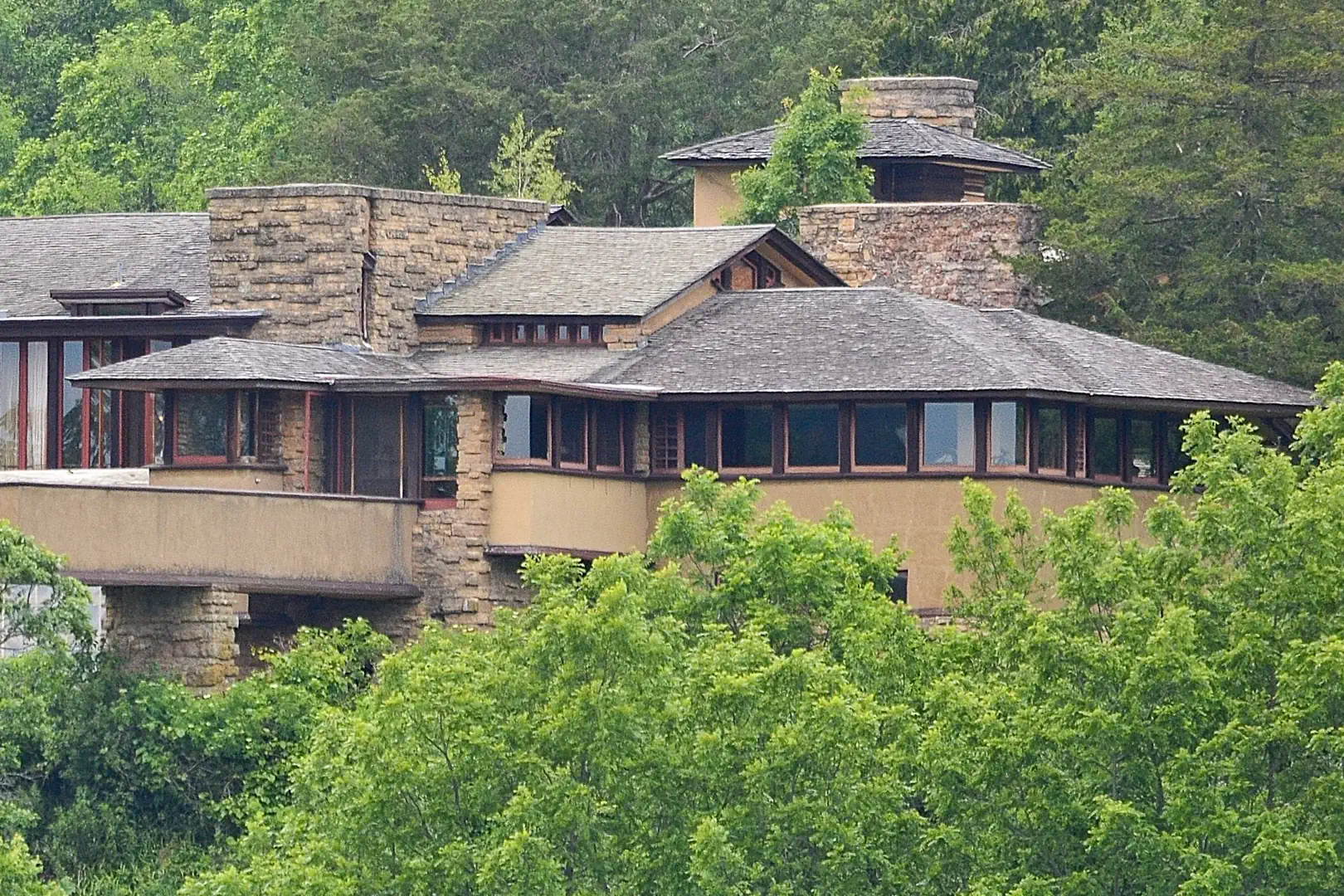
Frank Lloyd Wright’s Taliesin sits south of Spring Green, Wisconsin. Photograph by Stephen Matthew Milligan.
From there, I went south to County Trunk Highway C and then east to STH 23. At the corner of C and 23 sits Frank Lloyd Wright’s world-famous Taliesin. I didn’t stop at the visitor center to get tickets for the tour of the 800-acre estate this time around; maybe next time.
Less than a mile south along STH 23, CTH Z swings east to CTH T. A quick jog on Coon Rock Road leads to Amacher Hollow Road, which picks up CTH H, CTH HH, and onto Knight Hollow Road. These are all fantastic, well-paved cross-country roads with lots of curves and sweepers draped over rolling hills through open farm country and standing timber. Knight Hollow Road picks up CTH K, to CTH KK, to CTH F, which leads up the soaring Blue Mounds to Brigham Park.
Wisconsin is a haven for diverse wildlife. I tend to keep my riding speed down on its back roads because that wildlife tends to want to share the roads with motorcycles. Usually, I encounter wild turkeys and whitetail deer on fall rides, though not this time. In a very unusual occurrence, I had two close encounters with mature bald eagles, complete with vivid white head and tail plumage. I spotted one on CTH C and another on Coon Rock Road.
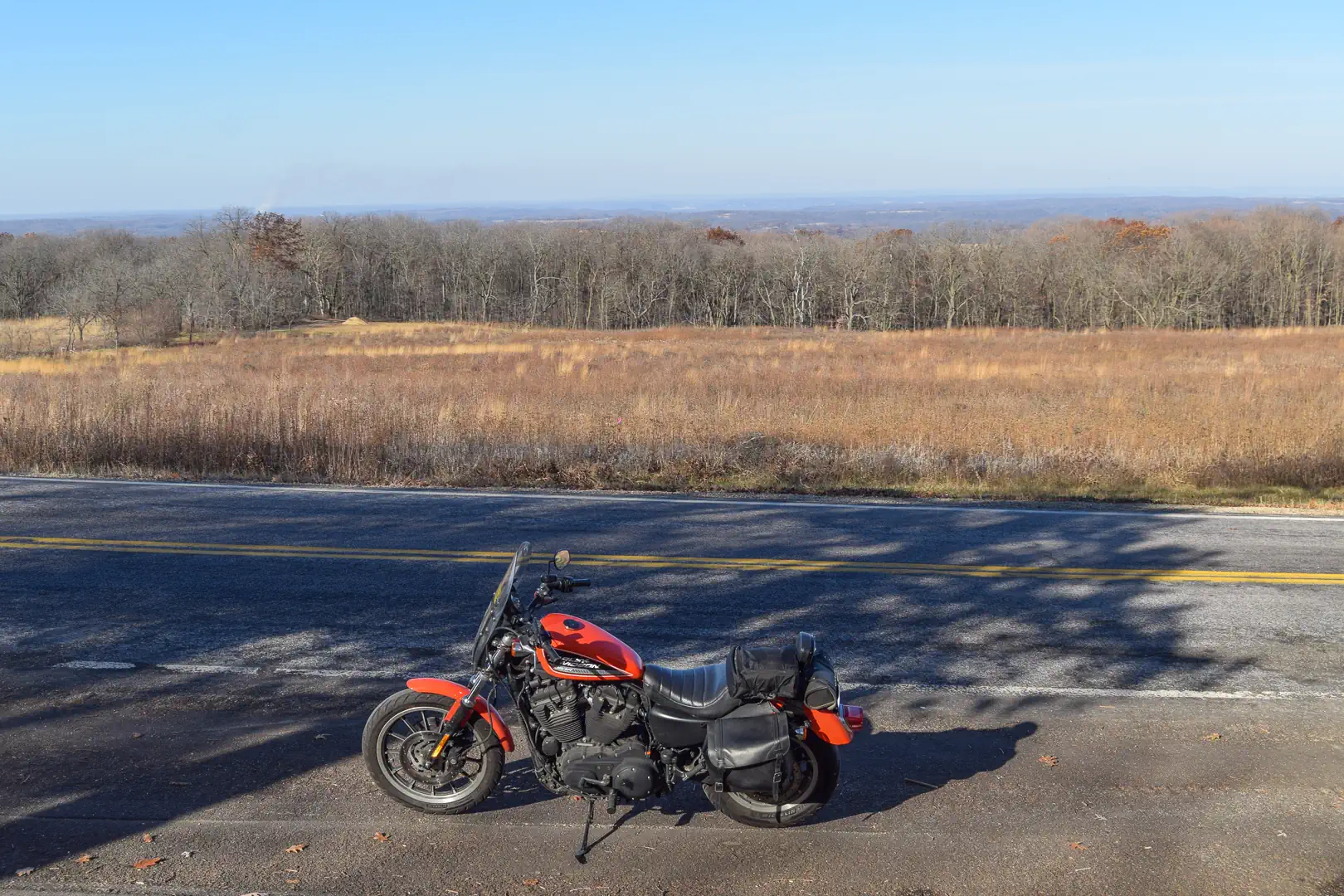
This is the view north from Brigham Park in Dane County. Author Peter Egan has written that it is “one of the finest views on earth.” Agreed.
Raptors such as the bald eagle are well-known as magnificent birds of prey, thanks to videos of them swooping down on a river and plucking fish from the water with their powerful talons. They are less often portrayed in their other role as scavengers with no compunctions about dining on roadkill, which is what each bird was doing when I rolled up. The white feathers made each easy to see against the shadowy roadside. Neither posed a hazard, though each did fly out in front of me after I had slowed to a walk. It was unusual to see two eagles and get so close to them, and great to see them.
Brigham Park sits atop the Blue Mounds, a few miles west of Mount Horeb, Wisconsin, offering a panoramic view to the north of the Wisconsin River valley. The Baraboo Range rises at the far edge of the view north. In his short story, “Ride Hard, Ride Short,” for Cycle World magazine in January 2001, Peter Egan said of this vista, “It is, to my mind, one of the finest views on earth.” Anyone who has seen it will probably agree, especially on a day like this.
Brigham Park is situated only about a quarter-mile north of the site of Fort Blue Mounds, which played an essential role in the Black Hawk War of 1832. That summer-long war was the last major conflict between the U.S. government and Native tribes—in this case, mainly the Sauk and Fox tribes—east of the Mississippi in the old Northwest Territory.
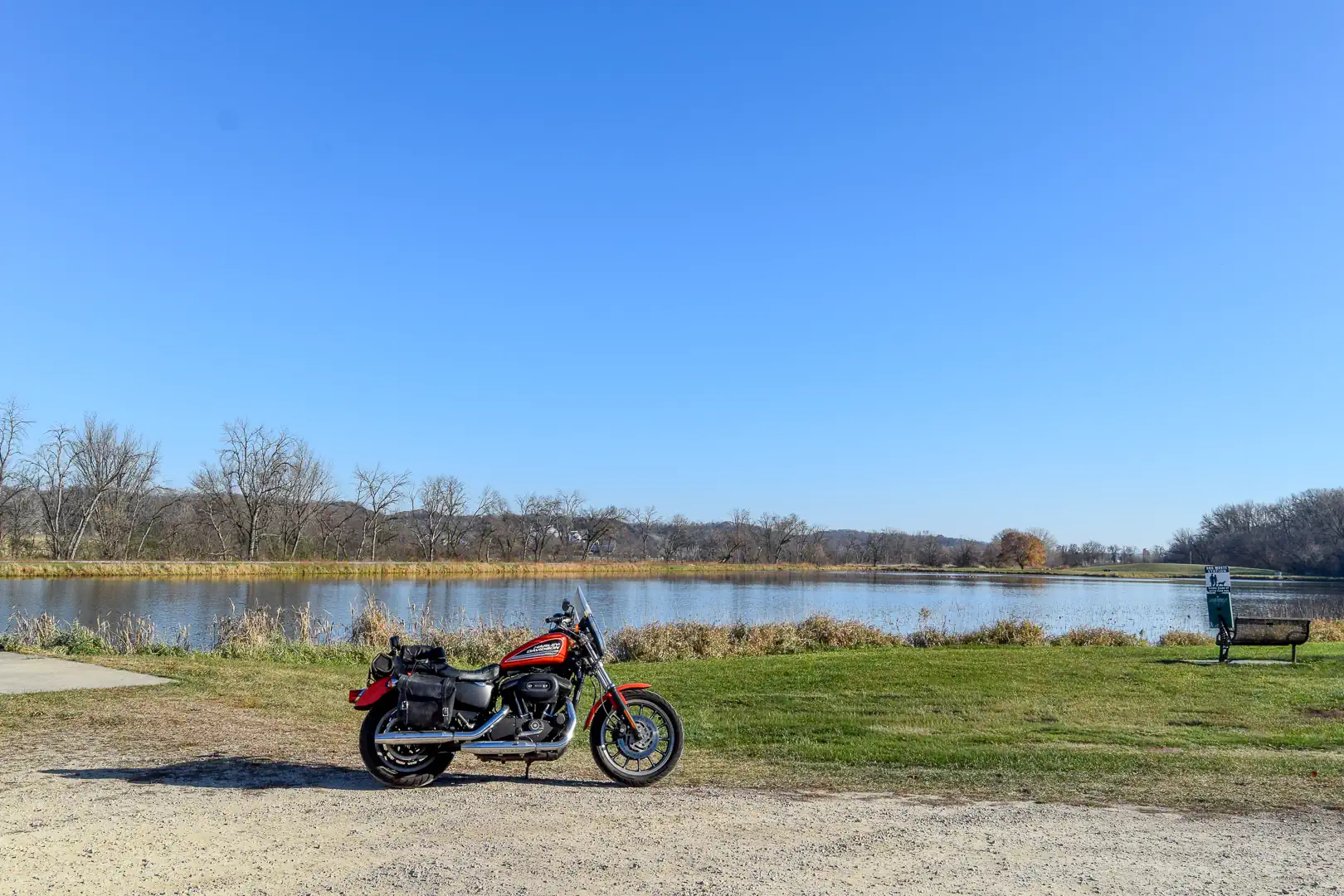
Lake Marion near Mazomanie looks summery, shimmering under warm, blue skies. Years ago, the author lived in Mazomanie and ran along the railroad grade on the far shore.
Reversing course north along CTH F all the way to just north of Black Earth, WI, then north along CTH KP, glistening Lake Marion comes into view south of Mazomanie.
A small, man-made body of water, Lake Marion is the setting for a park that stretches along its western shore, and it holds many memories for me. I lived in Mazomanie in the 1970s and ‘80s, and often ran along the railroad grade that borders the lake shore to the east.
As the afternoon drew down, the shadows grew longer, so it was time to head back home west along STH 14.
The entire loop is only 82 miles, which the fuel-injected Sportster covered at a relaxed pace, using only 1.5 gallons of gas—54.6 mpg. As short a day-trip tour as the Blue Mounds Loop was, I relished the pure pleasure of having such great weather in November. Unfortunately, reality is only a forecast away. The forecast for the coming week has daytime highs stuck in the 40s. While I’ll still do some riding, I’ll be thinking of spring.
2027 Suzuki GSX-R1000R + BTR Build Off Winner + Brian Bentley and the Ducati 916
byMotos and Friends by Ultimate Motorcycle
Hello and welcome again to the Motos and Friends Podcast. This episode is brought to you by Leod Escapes. My name is Arthur Coldwells.
* * * * *
Have you ever wanted to ride a real MotoGP track? Well, here’s your chance! Leod Escapes does all sorts of amazing European tours, including the incredible Munich to Mugello tour at the end of June, or you can try the Core of Catalunya or the Portimão Andalusia trips, both in October. These are incredible touring experiences with the very best that Europe has to offer, as well as riding these amazing tracks on brand new BMW S1000RRs. So for the trip of a lifetime, visit LeodEscapes.com, now!
* * * * *
In our first segment, Nic de Sena tells us all about his recent trip to Spain to ride the new 2027 Suzuki GSX-R1000R. Suzuki did a slightly different spin on this particular launch where they split the journalists into teams of 3, and had a 6-hour endurance ‘race’ to see how well everyone fared. Nic gives us the lowdown on what it’s like to the new Gixxer and for such long track sessions!
Rider Market from just outside Orlando, Florida, is the winner of the recent Royal Enfield BTR Build-Off competition in the Road Race category. Brian Koster is the Parts Director at Rider Market and he tells us briefly about the machine and parts he selected that made this retro-looking Royal Enfield stand out and take the trophy.
Our guest for this episode is Brian Bentley. A few years ago, just prior to Covid, Brian had a chance to buy a Ducati 916. He’s always been a major fan of the bike ever since it launched in the early nineties. He’d actually been looking for a 748 for a while, but when this great example came to his attention he couldn’t resist. The only snag was that it was completely disassembled. So, Brian did what any reasonable bike-fanatic would do: he loaded all the endless boxes of parts into the trunk of his SUV, headed home to Daytona Beach, and started the build. Brian recounts the story of this incredible machine and what eventually happened to it in the end.
* * * * *
Here’s quick reminder to check out our monthly digital magazine. It’s filled with everything you want to read on motorcycling, including some things you’ve probably not seen elsewhere. It’s absolutely free and you will find it on the Apple App Store and of course on Google Play as well.
Don’t forget to leave us your comments on our social media—we’re on all the usual platforms at Ultimate Motorcycling. We love hearing your feedback… so good or bad, please let us know what you think. If there’s something you’d like us to cover, we’d love to hear those ideas too!
We use cookies and browser activity on this website
Functional
Always active
The technical storage or access is strictly necessary for the legitimate purpose of enabling the use of a specific service explicitly requested by the subscriber or user, or for the sole purpose of carrying out the transmission of a communication over an electronic communications network.
Preferences
The technical storage or access is necessary for the legitimate purpose of storing preferences that are not requested by the subscriber or user.
Statistics
The technical storage or access that is used exclusively for statistical purposes.The technical storage or access that is used exclusively for anonymous statistical purposes. Without a subpoena, voluntary compliance on the part of your Internet Service Provider, or additional records from a third party, information stored or retrieved for this purpose alone cannot usually be used to identify you.
Marketing
The technical storage or access is required to create user profiles to send advertising, or to track the user on a website or across several websites for similar marketing purposes.